
One of Mother Nature’s most soothing yet exhilarating and beautiful creations in the world is the waterfall. There is just something mesmerizing about watching water tumble off a rock face into a pool or raging river beneath. The noise it makes, the sheer volume of water – it’s magical. There are thousands and thousands of waterfalls strewn across the world, but not all are created equal.
1. Iguazu Falls, Argentina/Brazil

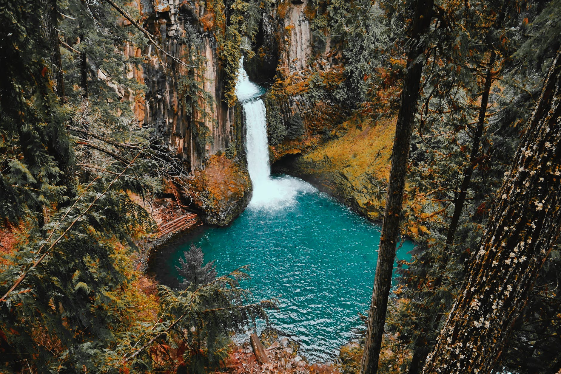
The staircase character of the falls consists of a two-step waterfall formed by three layers of basalt. The steps are 35 and 40 metres in height. The columnar basalt rock sequences are part of the 1,000-metre-thick Serra Geral Formation within the Paleozoic–Mesozoic Paraná Basin. The tops of these sequences are characterized by 8–10 m of highly resistant vesicular basalt and the contact between these layers controls the shape of the falls. Headwater erosion rates are estimated at 1.4–2.1 cm/year
The Iguazu Falls are located where the Iguazu River tumbles over the edge of the Paraná Plateau, 23 kilometres upriver from the Iguazu’s confluence with the Paraná River.Numerous islands along the 2.7-kilometre-long edge divide the falls into many separate waterfalls and cataracts, varying between 60 and 82 m high. The number of these smaller waterfalls fluctuates from 150 to 300, depending on the water level. About half of the river’s flow falls into a long and narrow chasm called the Devil’s Throat.
The Devil’s Throat canyon is 80–90 m wide and 70–80 m deep. Left of this canyon, another part of the river forms 160-200 individual falls, which merge into a single front during flood stage. The largest falls are named San Martín, Adam and Eva, Penoni, and Bergano.
About 900 m of the 2.7 km length does not have water flowing over it. The water of the lower Iguazu collects in a canyon that drains into the Paraná River, a short distance downstream from the Itaipu Dam. The junction of the water flows marks the border between Brazil, Argentina, and Paraguay. The surrounding environs of jungly rainforest are equally beautiful, creating a magical memory you won’t ever forget. The falls are protected in a national park and can be viewed from either the Argentine or Brazilian side.
The Iguazu National Park consists of two national parks, one in Foz de Iguazu and the other one in Puerto Iguazu . The curious thing is that although one only sees the falls as the main attraction, the park has a size of 252,982 hectares.
These falls in Argentina and Brazil managed to attract so much attention that almost at the same time they were declared National Parks . And after some years and millions of visitors fascinated by the landscape and the sound of this natural attraction, UNESCO declared them as World Heritage Site in 1984, and reaffirmed as Exceptional Universal Value in 2013.
2. Victoria Falls, Zimbabwe/Zambia

On the Zambezi River between Zimbabwe and Zambia, the UNSECO World Heritage site of Victoria Falls is one of the planet’s most beautiful and impressive waterfalls. It’s known locally as “The Smoke that Thunders.” It provides habitat for several unique species of plants and animals with a width of 1,708 metres.
During the rainy season, you can expect to get soaked walking along the trail on the Zimbabwe side, where the best views of the falls are found.
The Zambia side takes you up close and personal with the impressive wall of water that plunges over a 1.7-kilometer-wide precipice that is more than 100 meters deep. You can even swim in Devil’s Pool, which is literally at the top of the falls on the Zambian side.
Victoria Falls is a waterfall on the Zambezi River in southern Africa,.
The nearby national park in Zambia is named Mosi-oa-Tunya, whereas the national park and town on the Zimbabwean shore are both named Victoria Falls.
While it is neither the highest nor the widest waterfall in the world, Victoria Falls is classified as the largest, based on its combined width of 1,708 metres and height of 108 metres resulting in the world’s largest sheet of falling water. Victoria Falls is roughly twice the height of North America’s Niagara Falls and well over twice the width of its Horseshoe Falls. In height and width Victoria Falls is rivalled only by Argentina and Brazil’s Iguazu Falls.
During the flood season, however, it is impossible to see the foot of the falls and most of its face, and the walks along the cliff opposite it are in a constant shower and shrouded in mist. Close to the edge of the cliff, spray shoots upward like inverted rain, especially at Zambia’s Knife-Edge Bridge.
Victoria Falls presents a spectacular sight of awe-inspiring beauty and grandeur on the Zambezi River, forming the border between Zambia and Zimbabwe. It was described by the Kololo tribe living in the area in the 1800s as ‘Mosi-oa-Tunya’ – ‘The Smoke that Thunders’. In more modern terms Victoria Falls is known as the greatest curtain of falling water in the world.
Columns of spray can be seen from miles away as, at the height of the rainy season, more than five hundred million cubic meters of water per minute plummet over the edge, over a width of nearly two kilometres, into a gorge over one hundred meters below.
Facing the Falls is another sheer wall of basalt, rising to the same height, and capped by mist-soaked rain forest. A path along the edge of the forest provides the visitor prepared to brave the tremendous spray, with an unparalleled series of views of the Falls.
One special vantage point is across the Knife-edge Bridge, where visitors can have the finest view of the Eastern Cataract and the Main Falls as well as the Boiling Pot, where the river turns and heads down the Batoka Gorge. Other vantage points include Livingstone Island, the Falls Bridge, Devils Pool and the Lookout Tree, both of which command panoramic views across the Main Falls.
3. Havasu Falls, Arizona, USA

Havasu Falls is the most beautiful of the five Havasupai Waterfalls that plummet over orange-red cliffs into bright turquoise-blue pools in a side canyon of the Grand Canyon. The number of people allowed into the canyon is limited, and there is often a waiting list to experience this bucket-list worthy waterfall.
Havasu Falls is located 2.4 km from Supai. It is the more famous and most visited of the various falls along Havasu Creek. It consists of one main chute that drops over a 27 to 30 m vertical cliff into a series of plunge pools. High calcium carbonate concentration in the water creates the vivid blue-green color and forms the natural travertine dams that occur in various places near the falls.
Due to the effects of flash floods, the appearance of Havasu Falls and its plunge pools has changed many times.[3] Prior to the flood of 1910, water flowed in a near continuous sheet, and was known as Bridal Veil Falls.[4] The notch through which water flows first appeared in 1910, and has changed several times since. Water currently flows as one stream. In the past, there were sometimes multiple streams, or a continuous flow over the edge.
There are many picnic tables on the opposite side of the creek, and it is easy to cross over by following the edges of the pools. It is possible to swim behind the falls and enter a small rock shelter behind it. However, drownings have occurred.[6] From the trail head parking lot, until the Supai Village, there is no access to drinking water. Hikers are advised to bring their own water with them. In the town of Supai, there is a general store and cafe where food and beverage can be purchased.
4. Angel Falls, Venezuela

Located in Venezuela, Angels Falls is the world’s highest waterfall at a staggering 979 meters .This is 15 times higher than Niagara Falls for comparison. The water comes from the Churun River and does a free-fall drop over the edge of a mountain into a set of white water rapids below. There is a second drop of 30 meters just beyond the rapids.
To reach the falls, however, is no easy feat. The waterfall has been known as the Angel Falls since the mid-20th century; they are named after Jimmie Angel, a US aviator, who was the first person to fly over the falls.
They were not known to the outside world until American aviator Jimmie Angel.
The name of the waterfall “Salto del Ángel” was first published on a Venezuelan government map in December 1939. It’s a landscape so dense and diverse that it’s like a botanical Mandelbrot: from a distance trees, on which grow succulents and ferns, on which grow mosses and creepers, on which grow small shoots of verdure, on which feed a dazzling array of bugs – and so on ad infinitum. It’s worth the effort to get there – an effort we thought we’d achieved after a three-day journey of planes, strains and automobiles that delivered us to the shores of Cainama Lagoon and the faded grandeur of Waku Lodge. Just one boat ride to go, and we’d reach the fabled falls, known hereabouts as Salto Angel.
“It’s a long day,” said our Waku host, Pablo, whose calm demeanour and proven ability to fix all problems instilled in us unquestioning faith. “And the men on board will have to push the boat through shallow sections because, right now, the water is low.”
5. Niagara Falls, USA/Canada

It isn’t the tallest waterfall in the world, but Niagara Falls is certainly impressive in its scope and power. Niagara Falls is comprised of three waterfalls, the largest of which is Horseshoe Falls. Straddling the border between the USA and Canada, the water cascades 614 feet down Niagara Gorge.
The falls can be viewed from a number of viewpoints in New York and Ontario. Cave of the Winds is one of the most unique viewpoints. Here, you will descend 175 feet into the Niagara Gorge to experience the power of the falls mid-flow from the Hurricane Deck. You’ll be given a rain jacket because you will get wet.
Niagara Falls is famed both for its beauty and as a valuable source of hydroelectric power. Balancing recreational, commercial, and industrial uses has been a challenge for the stewards of the falls since the 19th century.
Niagara Falls State Park was designed by Frederick Law Olmsted; he also designed Central Park in New York City.
Niagara Falls State Park is the oldest state park in America, established in 1885 as the Niagara Reservation. Over 8 million visitors explore Niagara Falls State Park annually.
Niagara Falls is comprised of three waterfalls, from largest to smallest, the Horseshoe Falls , American Falls and Bridal Veil Falls. Niagara Falls’ vertical height is over 176 feet in some sections.The American and Bridal Veil Falls were turned off in 1969 by the U.S. Army Corps. of Engineers to study the effects of erosion. There are plans to “turn off” the Falls again to rebuild two, 115-year-old bridges.
Niagara Falls’ current erosion rate is approximately 1 foot per year and could possibly be reduced to 1 foot per 10 years due to flow control and diversion for hydro-power generation. The water that flows over Niagara Falls is at 25-50% capacity at any given time. Cave of the Winds, located at Niagara Falls State Park is torn down and re-built every year. The birth of Niagara Falls can be traced back more than 12,000 years to the end of the last glacial period.
Despite myths to the contrary, Niagara Falls does not freeze in the winter. However, the flow of water was reduced to a mere trickle for a few hours on March 29, 1848 because of an ice jam upstream in the Niagara River. During periods of peak flow in the summer and fall, more than 700,000 gallons of water per second pour over Niagara Falls.
Superior, Michigan, Huron and Erie of the five Great Lakes drain into the Niagara River, before emptying into Lake Ontario. These five Great Lakes make up almost one-fifth of the world’s fresh water supply.
Niagara Falls is not the tallest waterfall in the world; however, the beauty of the falls comes from the height and the incredible volume of water running over the falls at a given time.Fish travel over Niagara Falls and most survive because of their ability to flow with the water.Energy from the Niagara River has been harnessed for hydro-electric power generation as far back as the mid-eighteenth century.
Power generation facilities along the Niagara River supply more than one-quarter of all power used in New York State and Ontario. 50 to 75 percent of the water flowing along the Niagara River is diverted from going over the Falls to hydroelectric power generating stations. One of the oldest surviving United States flags is permanently displayed at Old Fort Niagara. It was captured by the British during the War of 1812. The original Flight of Five locks that were built in 1840 still exist along the Erie Canal in Lockport.
6. Dudhsagar Falls, India

Dudhsagar Falls also known as the Sea of Milk is referred to as India’s highest waterfalls which is approximately 310 meters high and 30 meters wide.
One of India’s tallest and most impressive waterfalls, Dudhsagar Falls cascades down more than 1,000 feet in four tiers at nearly 100 feet wide. The speed and force with which the water falls and sprays also gives Dudhsagar Falls its “sea of milk” nickname because this is the illusion it creates dropping into the Mandovi River below.
The falls are located in India’s Goa province inside the Bhagwan Mahaveer Sanctuary, about 60 kilometers from Panjum and 45 kilometers from Mudgaon.
The falls is located in the Bhagwan Mahaveer Sanctuary and Mollem National Park among the Western Ghats. The waterfall forms the border between Karnataka and Goa states.The falls is a punctuation mark in the journey of the Mandovi River from the Western Ghats to Panjim where it meets the Arabian sea. The area is surrounded by deciduous forests with rich biodiversity.This waterfalls is also known as Tambdi Surla to some of the local people.
One can reach the Dudhsagar Waterfalls with the help of Bhagwan Mahavir Wildlife sanctuary Taxi near a Goan Village called Molem. This Association will take you through lush green forest and some heavy flowing streams and get back to you same place. Currently, this is the only access to the Waterfall.
7. Kaieteur Falls, Guyana

Kaieteur Falls is the world’s largest single drop waterfall by the volume of water flowing over it. Located on the Potaro River in the Kaieteur National Park, it sits in a section of the Amazon rainforest included in the Potaro-Siparuni region of Guyana. It is 226 metres high when measured from its plunge over a sandstone and conglomerate cliff to the first break. It then flows over a series of steep cascades that, when included in the measurements, bring the total height to 251 metres . While many falls have greater height, few have the combination of height and water volume, and Kaieteur is among the most powerful waterfalls in the world with an average flow rate of 663 cubic metres per second . From the airstrip landing, it’s a 15-minute walk to the top of the falls.
Kaieteur Falls is about four times higher than Niagara Falls, on the border between Canada and the United States, and about twice the height of Victoria Falls, on the border of Zambia and Zimbabwe in Africa. It is a single drop waterfall.
Upriver from the falls, the Potaro Plateau stretches out to the distant escarpment of the Pakaraima Mountains. The Potaro River empties into the Essequibo River which is one of the longest and widest rivers in South America and the longest river in Guyana
Deep within Guyana’s region of the Amazon Forest lies Kaieteur National Park, home to a gargantuan cataract sharing the park’s name. Rivaled by few in the world when taken into account its combined height and the sheer volume of water from the Potaru River flowing over its precipice at any given moment, Kaieteur Falls further distances itself from the crowd of most spectacular waterfalls in the world for its remoteness. Surrounded by pristine rainforest, simply reaching this wonder requires hiring a tour company that will charter a plane in order to even reach a trekking point that accesses the falls.
A pair of similar legends further contribute to the Falls’ mystique. According to local Patoma Indian lore, chief Kai saved his people by paddling over the precipice in an act of self-sacrifice to the spirit Makonaima. The second version is slightly less altruistic, as relayed by geologist Charles Barrington Brown in his account from when he “discovered” the waterfall on an expedition in 1870; Brown was told by Amerindians that a despised old man was put in a boat by relatives eager to be rid of him, and unceremoniously pushed into the current, which lent the falls their current name translating to “old-man-fall.”
Wear sturdy shoes to visit Kaieteur Falls, as there are uneven pathways to navigate between the three different lookouts. You will spend around 2 hours on the ground before flying back to Georgetown or onwards to another destination depending on your day tour package. The first major stop along the way was at the so-called Boy Scout’s View. From here, we were able to get our first frontal look at the falls on land.
The overlook got its name because local boy scout troops were initiated only after hiking from the bottom to this viewpoint at the top of the gorge. Given the height of the ledge we were on, this hike must’ve been a pretty big deal.
8. Yosemite Falls, California, USA

Yosemite Falls is the highest waterfall in the world and the tallest in North America. Yosemite National Park is an American national park located in the western Sierra Nevada of Central California, bounded on the southeast by Sierra National Forest and on the northwest by Stanislaus National Forest. Located in stunning Yosemite National Park, Yosemite Falls consists of three separate falls with a drop of 2,425 feet that give the illusion of one giant cascade of water.
Yosemite Falls is fed by snowmelt, so to see it at its fullest, visit in late spring or early summer when you can hear it thunder from across Yosemite Valley. A very small number of rock climbers have taken the opportunity to climb the normally inaccessible rock face beneath the falls, although this is an extraordinarily dangerous undertaking; a single afternoon thunderstorm could restart the falls, sweeping the climbers off the face.
The park is managed by the National Park Service and covers an area of 748,436 acres and sits in four counties: centered in Tuolumne and Mariposa, extending north and east to Mono and south to Madera County. Designated a World Heritage site in 1984, Yosemite is internationally recognized for its granite cliffs, waterfalls, clear streams, giant sequoia groves, lakes, mountains, meadows, glaciers, and biological diversity. Almost 95% of the park is designated wilderness.
The geology of the Yosemite area is characterized by granitic rocks and remnants of older rock. About 10 million years ago, the Sierra Nevada was uplifted and then tilted to form its relatively gentle western slopes and the more dramatic eastern slopes. The uplift increased the steepness of stream and river beds, resulting in the formation of deep, narrow canyons. About one million years ago, snow and ice accumulated, forming glaciers at the higher alpine meadows that moved down the river valleys. Ice thickness in Yosemite Valley may have reached 4,000 feet during the early glacial episode. The downslope movement of the ice masses cut and sculpted the U-shaped valley that attracts so many visitors to its scenic vistas today.
The name “Yosemite” originally referred to the name of a tribe which was driven out of the area by the Mariposa Battalion. Previously, the area had been called “Ahwahnee” by indigenous people.
Yosemite is home to countless waterfalls. Peak runoff typically occurs in May or June, with some waterfalls often only a trickle or completely dry by August. Storms in late fall rejuvenate some of the waterfalls and all of them accumulate frost along their edges many nights during the winter.
It was popularized and attracted tourists from across the country in the latter half of the 19th century. With such a ground swell of visitation and interest, this established the chain of events that would ultimately result in The Yosemite becoming a California State Park in 1864 .
The falls consist of three sections:
The first stage is the Upper Fall, which is said to plunge 1,430ft.
The second stage is the Middle Cascades, which tumbles down a height of reportedly 675ft.
The final stage is the Lower Fall, which is said to drop 320ft.
9. Plitvice Waterfalls, Croatia

Plitvice Lakes National Park is one of the oldest and largest national parks in Croatia. In 1979, Plitvice Lakes National Park was added to the UNESCO World Heritage register.
The national park was found in 1949 and is in the mountainous karst area of central Croatia, at the border to Bosnia and Herzegovina. The important north–south road that passes through the national park area connects the Croatian inland with the Adriatic coastal region.
The protected area extends over 296.85 square kilometres. About 90% of this area is part of Lika-Senj County, while the remaining 10% is part of Karlovac County.
Each year, more than 1 million visitors are recorded.
They are separated by natural dams of travertine, which is deposited by the action of moss, algae, and bacteria. The particularly sensitive travertine barriers are the result of an interplay between water, air and plants.
16 lakes are separated into an upper and lower cluster formed by runoff from the mountains, descending from an altitude of 636 to 503 m. The lakes collectively cover an area of about 0.77 square miles, the water exiting from the lowest lake forming the Korana River.
The lakes are renowned for their distinctive colors, ranging from azure to green, grey or blue. The colors change constantly depending on the quantity of minerals or organisms in the water and the angle of sunlight. It is located roughly halfway between capital city Zagreb and Zadar on the coast, the lakes are a definite must-see in Croatia.
The beauty of 16 lakes are inter-connected by a series of waterfalls, and set in deep woodland populated by deer, bears, wolves, boars and rare bird species. The National Park covers a total area of 300 square kilometres, whilst the lakes join together over a distance of eight kilometres. It’s probably one of the more memorable waterfall attractions in the world .
10. Fall Creek Falls, Tennessee, USA

Fall Creek Falls, at 256 feet, is one of the highest waterfalls in the eastern United States. Other waterfalls within the park include Piney Falls, Cane Creek Falls, and Cane Creek Cascades. The park is located in Bledsoe and Van Buren counties, 11 miles east of Spencer and 18 miles west of Pikeville. It is located in the eastern portion of the rugged Cumberland Plateau in Tennessee, the waterfalls are part of Fall Creek Falls State Park and can be accessed via a three-mile round-trip hike that gains about 715 feet total.
Beyond the main falls, the park is home to five other beautiful waterfalls, as well as cascades, gorges, and 34 miles of hiking trails. You can even stay in a cabin or campsite. Fall Creek Falls State Park is one of Tennessee’s largest and most visited state parks. The park encompasses more than 29,800 acres.. Laced with cascades, gorges, waterfalls, streams and lush stands of virgin hardwood timber, the park beckons those who enjoy nature at her finest.
Fall Creek Falls State Park is one of the most scenic and spectacular outdoor recreation areas in America. Fall Creek Fallsis the highest free-fall waterfall east of the Mississippi River.
The Cane Creek Gorge presents as a large gash in the western edge of the Cumberland Plateau, stretching for some 15 miles from the Cane Creek Cascades to Cane Creek’s mouth along the Caney Fork River. Cane Creek rises atop Little Mountain — which lines the plateau’s eastern edge above Sequatchie Valley — and winds northward across the plateau.
Just beyond its source, Cane Creek slowly gains strength as it absorbs Meadow Creek and several smaller streams. As the creek enters the gorge, it drops several hundred feet in less than a mile, including 45 feet over Cane Creek Cascades and 85 feet over Cane Creek Falls. A few hundred meters north of Cane Creek Falls, Rockhouse Creek spills 125 feet over a plunge waterfall. Over the next half-mile, Cane Creek absorbs Fall Creek and Piney Creek, both of which enter from smaller gorges to the immediate west. During this stretch, part of the creek disappears underground into limestone sinks and reemerges at a spring known as “Crusher Hole.” Cane Creek continues to lose elevation before steadying near its confluence with Dry Fork. Beyond Dry Fork, the creek gradually descends to the Highland Rim, where it empties into the Caney Fork River.
The man-made Fall Creek Falls Lake, controlled by a dam, assures continuing flow of water to Fall Creek Falls. The lake dominates the park’s southern section.
A pine-hardwood forest covers much of the tabletop plateau above the falls. There is a rich mixed mesophytic forest in the gorges, and old-growth mixed mesophytic forest occur in four areas of the gorge. In the 1950 classic work “Deciduous Forests of the Eastern United States,” ecologist Lucy Braun described the forest at Fall Creek Falls as including tulip poplar, basswood, buckeye, northern red oak, white oak, hickories, eastern hemlock, and American beech, among many other species. This type of forest is the most diverse forest in the eastern United States and has more dominant canopy species than any other deciduous forest type.”