
Monument is an object, especially large and made of stone, built to remember and show respect for a person or group of people, or a special place made for this purpose. It is an old building or place that is an important part of a country’s history. Here are Beautiful 10 Monuments in the World.
- Macchu Picchu, Peru

Machu Picchu is one of the most important archaeological sites in the world. The complex of palaces and plazas, temples and homes may have been built as a ceremonial site, a military stronghold, or a retreat for ruling elites. Its dramatic location is certainly well suited for any of those purposes. Machu Picchu is an old Inca citadel in Peru, on a 2,430-metre (7,970 ft) mountain ridge, South America. It was built in the 15th century and is 2,430 metres above sea level. It is referred to as the ‘Lost City of the Incas’. Bingham spent most of his life arguing that Machu Picchu and Vilcabamba were one and the same. Machu Picchu was included in the list of the New Seven Wonders of the World and was declared a UNESCO World Heritage Site in 1983. The three most visible structures in Machu Picchu are the Inti Watana, the Temple of the Sun and the Room of the Three Windows. The peak is accessible by trek or by train and attracts millions of visitors every year. It is necessary to preserve these monuments to ensure that even in the future, people can still marvel at their magnificence. It is located in the Machu Picchu District within Urubamba Province, part of Cusco Region, above the Sacred Valley. Machu Picchu was built in the classical Inca style, with polished dry-stone walls. Most of the outlying buildings have been reconstructed in order to give tourists a better idea of how they originally appeared. In 2007, Machu Picchu was voted one of the New Seven Wonders of the World in a worldwide internet poll.
When an earthquake occurs, the stones in an Inca building are said to “dance;” that is, they bounce through the tremors and then fall back into place. Without this building method, many of the best known buildings at Machu Picchu would have collapsed long ago. While the Inca are best remembered for their beautiful walls, their civil engineering projects were incredibly advanced as well. You can walk up to the ruins. The steep path roughly follows Hiram Bingham’s 1911 route and offers extraordinary views of the Machu Picchu Historical Sanctuary, which looks almost as it did in Bingham’s time. The climb is strenuous and takes about 90 minutes. There’s a great, hidden museum but no one goes there. For visitors conditioned to the explanatory signs at national parks, one of the strangest things about Machu Picchu is that the site provides virtually no information about the ruins. There’s more than one peak to climb. There’s a secret temple. Visitors have understood that the ruins’ natural setting is as important to the site as the buildings themselves.
2.Angkor Wat

The largest religious complex of the world by land area on a site measuring 162.6 hectares (1.626 km2 , 402 acres). The most significant monument of Southeast Asia is extensive of Angkor Wat is constructed as Hindu temple and dedicated to Lord Vishnu. It was gradually transformed into a Buddhist temple, its name, which translates to “temple city”. It serves as an important tourist attraction in Cambodia. The word “Angkor” means “capital city” in the Khmer language, while the word “Wat” means “temple.” Many Buddhists believe the temple’s construction was ordered by the god Indra, and that the work was accomplished in one night. However, scholars now know it took several decades to build Angkor Wat, from the design phase to completion. Its five towers are intended to recreate the five peaks of Mount Meru, while the walls and moat below honor the surrounding mountain ranges and the sea. The heart of the temple was the central tower, entered by way of a steep staircase, a statue of Vishnu at top. This tower “was at once the symbolic center of the nation”.
One chamber in the tower has a scene showing a traditional Khmer ensemble of musical instruments known as the pinpeat, which is made up of different gongs, xylophones, wind instruments and other percussion instruments. In the same chamber, there’s also an intricate scene featuring people riding horses between two structures, which might be temples. These two paintings are among 200 that have been discovered in Angkor Wat since 2010. It consists of scores of temples, hydraulic structures (basins, dykes, reservoirs, canals) as well as communication routes. For several centuries Angkor, was the centre of the Khmer Kingdom. With impressive monuments, several different ancient urban plans and large water reservoirs, the site is a unique concentration of features testifying to an exceptional civilization. The Deep in the forests of Cambodia’s Siem Reap province, the elegant spires of an ancient stone city soar skyward above the sprawling complex of Angkor Archaeological Park. A visit to Cambodia’s World Heritage Temples of Angkor complex is understandably high on the list for many travellers. Angkor Wat is the ultimate expression of Khmer genius is an awe inspiring temple that is stunning for both its grand scale and its incredible detail. Angkor Wat is built by Suryavarman II and is the earthly representation of Mount Meru, the Mount Olympus of the Hindu faith and the abode of ancient gods. The Cambodian god-kings of old each strove to better their ancestors’ structures in size, scale and symmetry, culminating in what is believed to be the world’s largest religious building.
3.potala palace

The Potala Palace, winter palace of the Dalai Lama since the 7th century, symbolizes Tibetan Buddhism and its central role in the traditional administration of Tibet. The complex, comprising the White and Red Palaces with their ancillary buildings, is built on Red Mountain in the centre of Lhasa Valley, at an altitude of 3,700m. The Jokhang Temple Monastery is an exceptional Buddhist religious complex. Norbulingka, the Dalai Lama’s former summer palace, constructed in the 18th century, is a masterpiece of Tibetan art. The beauty and originality of the architecture of these three sites, their rich ornamentation and harmonious integration in a striking landscape, add to their historic and religious interest. “Three Protectors of Tibet are “. Chokpori, just to the south of the Potala, is the soul-mountain of Vajrapani, Pongwari that of Manjusri, and Marpori, the hill on which the Potala stands, represents Avalokitesvara. The site on which the Potala Palace rises is built over a palace erected by Songtsen Gampo on the Red Hill.
The Potala contains two chapels on its northwest corner that conserve parts of the original building. One is the Phakpa Lhakhang, the other the Chogyel Drupuk. King Srong-brtsan-sgam-po commissioned the building of a palace in Lhasa. Significantly smaller and less elaborate than its 5-square-mile (13-square-km) successor, it was named the Potala (“Pure Land” or “High Heavenly Realm”) for reasons that are not historically documented, although Mount Potala in India seems the likely source. Tibetan Buddhists acknowledge the Dalai Lama as the incarnation of Avalokiteshvara , a bodhisattva whose home was on Mount Potala. Srong-brtsan-sgam-po’s palace was later destroyed, and in 1645 the fifth Dalai Lama ordered the construction of a ne The mausoleum of the fifth Dalai Lama (the Potala’s patron), located in the west of the palace stands five stories high, is overlaid with gold, diamonds, pearls, and many other precious gems, and expresses the high honor the people had for this Buddhist saint. The new Potala was built on Mar-po-ri . It has 1,000 rooms and covers over 13 hectares (32 acres). The stone walls measure 3 meters (10 feet) thick on average. The general structure of the Potala Palace is in two parts: The Red Palace and the White Palace. The beautiful murals inside the palace are not only attractive, but also tell the story of Tibet. The golden roof on the top of the Red Palace is worth seeing. The Red Palace is the higher of the two palaces. The White Palace was home to ten successive Dalai Lamas and their courts. It became the summer residence of the Dalai Lama, and the White Palace became known as the winter estate of this saint of Buddhism. Housed within this amazing stone and wood structure are articles and artifacts from Tibetan history, religion, and culture.
4.Teotihuacan

Teotihuacan is an ancient Mesoamerican city located in a sub-valley of the Valley of Mexico, which is located in the State of Mexico, 40 kilometres (25 mi) northeast of modern-day Mexico City. It was built by hand more than a thousand years before the swooping arrival of the Nahuatl-speaking Aztec. Teotihuacan is known today as the site of many of the most architecturally significant Mesoamerican pyramids built in the pre-Columbian Americas. Teotihuacan began as a religious center in the Mexican Highlands around the first century CE. It became the largest and most populated center in the pre-Columbian Americas. Teotihuacan was home to multi-floor apartment compounds built to accommodate the large population. The term Teotihuacan is also used for the whole civilization and cultural complex associated with the site. It is the most visited archaeological site in Mexico. Teotihuacan means “the place where the gods were created”. Teotihuacan is arranged in a grid layout that covers about 8 square miles (20 square kilometers). It contains around 2,000 single-story apartment compounds, as well as various pyramids, plazas, temples and palaces of nobles and priests. The city contains several large, important structures: The Pyramid of the Moon, the Pyramid of the Sun, the Ciudadela (“Citadel”) and the Temple of Quetzalcoatl. Surrounded by smaller pyramids and platforms, the Pyramid of the Moon is situated at the northern end of the Avenue of the Dead and faces south. Standing at 140-feet (43-meters) high with a base measuring 426 by 511 feet (130 by 156 meters), the Pyramid of the Moon is the second largest structure in Teotihuacan. “It was the largest city anywhere in the Western Hemisphere before the 1400s,” Cowgill says. “It had thousands of residential compounds and scores of pyramid-temples comparable to the largest pyramids of Egypt.” Its principal builders, evidence shows that Teotihuacan hosted a patchwork of cultures including the Maya, Mixtec, and Zapotec. The main excavations, performed by Professors Saburo Sugiyama of Aichi Prefectural University in Japan and Rubén Cabrera, a Mexican archaeologist, have been at the Pyramid of the Moon. It supports a population estimated at 125,000–200,000, making it, at the time, one of the largest cities in the world. It is the largest pre-Colombian site in the Americas and the largest and most visited cultural site.
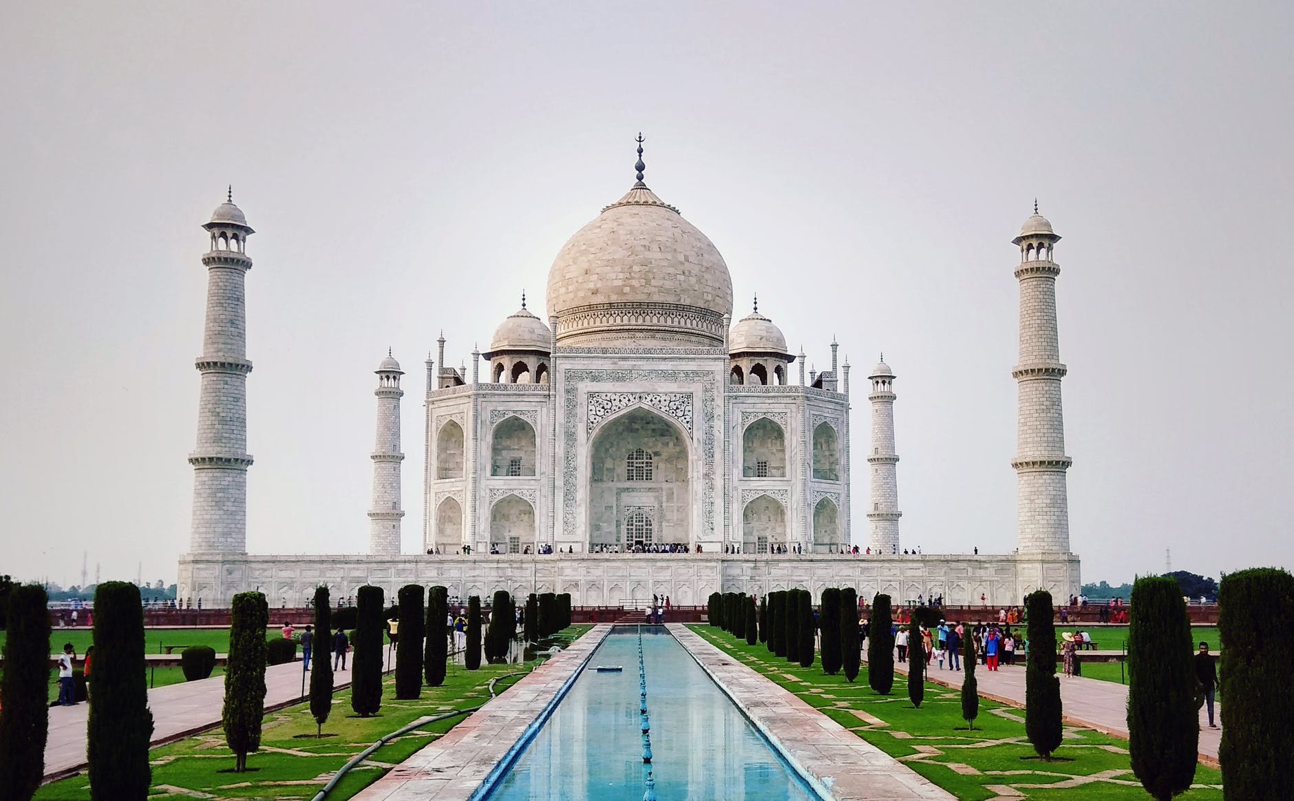
5.Taj Mahal

The Taj Mahal is located on the right bank of the Yamuna River in a vast Mughal garden that encompasses nearly 17 hectares, in the Agra District in Uttar Pradesh. It was built by Mughal Emperor Shah Jahan in memory of his wife Mumtaz Mahal with construction starting in 1632 AD and completed in 1648 AD, with the mosque, the guest house and the main gateway on the south, the outer courtyard and its cloisters were added subsequently and completed in 1653 AD. It was declared a winner of the New 7 Wonders of the World. Ustad-Ahmad Lahori was the main architect of the Taj Mahal. One of the most beautiful structural compositions in the world, the Taj Mahal is also one of the world’s most iconic monuments, visited by millions of tourists each year. For its construction, masons, stone-cutters, inlayers, carvers, painters, calligraphers, dome builders and other artisans were requisitioned from the whole of the empire and also from the Central Asia and Iran.
The Taj Mahal attracts 7–8 million visitors a year. More than 20,000 workers were employed from India, Persia, the Ottoman Empire, and Europe to complete the mausoleum. An area of 10,400 sq km around the Taj Mahal is defined to protect the monument from pollution. The Supreme Court of India delivered a ruling banning use of coal/coke in industries located in the Taj Trapezium Zone (TTZ) and switching over to natural gas or relocating them outside the TTZ. The Taj Mahal is considered to be the greatest architectural achievement in the whole range of Indo-Islamic architecture. Its recognised architectonic beauty has a rhythmic combination of solids and voids, concave and convex and light shadow; such as arches and domes further increases the aesthetic aspect. The uniqueness of Taj Mahal lies in some truly remarkable innovations carried out by the horticulture planners and architects of Shah Jahan. One such genius planning is the placing of tomb at one end of the quadripartite garden rather than in the exact centre, which added rich depth and perspective to the distant view of the monument. It is also, one of the best examples of raised tomb variety. The tomb is further raised on a square platform with the four sides of the octagonal base of the minarets extended beyond the square at the corners. The exterior of the tomb is square in plan, with chambered corners. The large double storied domed chamber, which houses the cenotaphs of Mumtaz Mahal and Shah Jahan, is a perfect octagon in plan. The exquisite octagonal marble lattice screen encircling both cenotaphs is a piece of superb workmanship. It is highly polished and richly decorated with inlay work. The borders of the frames are inlaid with precious stones representing flowers executed with wonderful perfection. The Taj Mahal is a perfect symmetrical planned building, with an emphasis of bilateral symmetry along a central axis on which the main features are placed. The building material used is brick-in-lime mortar veneered with red sandstone and marble and inlay work of precious/semi precious stones. The mosque and the guest house in the Taj Mahal complex are built of red sandstone in contrast to the marble tomb in the centre. The tomb, mosque, guest house, main gate and the overall Taj Mahal complex have maintained the conditions of authenticity at the time of inscription.
6.Great Wall of China

The Great Wall of China is the collective name of a series of fortification systems and one of the largest building-construction projects ever undertaken. Great Wall also contributed to the exploitation of farmland to the growth of the trade route that came to be known as the Silk Road. The Great Wall of China is one of the greatest sights in the world and the longest wall in the world, an awe-inspiring feat of ancient defensive architecture. Its winding path over rugged country and steep mountains takes in some great scenery and it can be visited by foreign travelers. The Great Wall actually consists of numerous walls, many of them parallel to each other, built over some two millennia across northern China and southern Mongolia. The height of the Great Wall is 5–8 meters (16–26 feet). The most extensive and best-preserved version of the wall runs for some 5,500 miles (8,850 km) east to west from Mount Hu near Dandong, southeastern Liaoning province, to Jiayu Pass west of Jiuquan, northwestern Gansu province. It is still one of the more remarkable structures on Earth.
The Great Wall was not just a wall. It was an integrated military defensive system with watchtowers for surveillance, fortresses for command posts and logistics, beacon towers for communications, etc. The Great Wall was designated a UNESCO World Heritage site in 1987. Nearly all 70 percent of the total length is actual constructed wall, with the small remaining stretches constituting ditches or moats and one-fourth of its length consists solely of natural barriers such as rivers and mountain ridges. The wall’s length without its branches and other secondary sections was thought to extend for some 4,160 miles (6,700 km). This Wall is to protect from their near neighbours as they were with the threat of barbarian invasions or raids. It’s long history is more than 2,300 years. It was built in different areas by different states/dynasties to protect different territorial borders. It’s often said that the First Emperor of Qin built the Great Wall. In the Qin Dynasty, the First Emperor of Qin started the northern walls to prevent invasion from northern nations. In the Han Dynasty, the emperors extended the Great Wall far into today’s western China to protect Silk Road trade.The Rock City of Petra
Rock City of Petra located about 115 miles (185 km) southwest of Amman, Jordan, Petra was an ancient city that was literally carved into red desert cliffs. Its ornate ancient architecture and natural beauty attract people from all over the world. In these early years the Nabataeans are believed to have lived a nomadic lifestyle, and Petra was likely a place of tents and simple structures. This would change as the caravan trade developed, with Petra serving as a center of trade between Arabia, Mesopotamia, Egypt and the eastern Mediterranean. The trading business gained the Nabataeans considerable revenue and Petra became the focus of their wealth. The Nabataeans were accustomed to living in the barren deserts, unlike their enemies, and were able to repel attacks by taking advantage of the area’s mountainous terrain. They were particularly skillful in harvesting rainwater, agriculture and stone carving. The city reached its peak about 2,000 years ago with a population estimated at 30,000 inhabitants. This process would see people abandon their tents for more permanent stone dwellings, in some instances carving them into the cliffs. A sophisticated plumbing system would also be built with a system of channels, pipes and cisterns to bring water to the people. Petra contains numerous tombs, most of them built at the edge of the city, beyond the main street. Some were simple, containing multiple burials in an unadorned rock chamber, while others were more spectacular. The best known tomb at Petra is called the “Khazneh,” which is Arabic for the “Treasury.” It is called this because at one time local people believed it contained hidden treasure.
Petra’s ancient inhabitants maintained a rich spiritual life. Three temples located near the main street. Its walls are still preserved up to a height of 75 feet (23 meters). A person would walk up 19 stairs before coming to a landing, than another eight steps, past a series of four columns, to arrive at the temple vestibule. Another structure, known to archaeologists at the “Great Temple,” contains a small theater in a design similar to a modern-day orchestra hall. The “Rose City” is a honeycomb of hand-hewn caves, temples, and tombs carved from blushing pink sandstone in the high desert of Jordan. it’s the raw beauty of Petra that draws in so many millions of visitors – the entire city of ruins is a work of art, painted on a natural stone backdrop that changes color every hour. The elegant Silk Tomb swirls with streaks of red, blue, and ocher, while vivid mosaics still pave the floors of a Byzantine-era church. Remember that Petra spreads out for over a hundred square miles—four times the size of Manhattan. While donkeys, camels, and horse buggies can hasten travel time between highlights, most of Petra’s sites are best reached on foot.
- The Rock City of Petra

Rock City of Petra located about 115 miles (185 km) southwest of Amman, Jordan, Petra was an ancient city that was literally carved into red desert cliffs. Its ornate ancient architecture and natural beauty attract people from all over the world. In these early years the Nabataeans are believed to have lived a nomadic lifestyle, and Petra was likely a place of tents and simple structures. This would change as the caravan trade developed, with Petra serving as a center of trade between Arabia, Mesopotamia, Egypt and the eastern Mediterranean. The trading business gained the Nabataeans considerable revenue and Petra became the focus of their wealth. The Nabataeans were accustomed to living in the barren deserts, unlike their enemies, and were able to repel attacks by taking advantage of the area’s mountainous terrain. They were particularly skillful in harvesting rainwater, agriculture and stone carving. The city reached its peak about 2,000 years ago with a population estimated at 30,000 inhabitants. This process would see people abandon their tents for more permanent stone dwellings, in some instances carving them into the cliffs. A sophisticated plumbing system would also be built with a system of channels, pipes and cisterns to bring water to the people. Petra contains numerous tombs, most of them built at the edge of the city, beyond the main street. Some were simple, containing multiple burials in an unadorned rock chamber, while others were more spectacular. The best known tomb at Petra is called the “Khazneh,” which is Arabic for the “Treasury.” It is called this because at one time local people believed it contained hidden treasure.
Petra’s ancient inhabitants maintained a rich spiritual life. Three temples located near the main street. Its walls are still preserved up to a height of 75 feet (23 meters). A person would walk up 19 stairs before coming to a landing, than another eight steps, past a series of four columns, to arrive at the temple vestibule. Another structure, known to archaeologists at the “Great Temple,” contains a small theater in a design similar to a modern-day orchestra hall. The “Rose City” is a honeycomb of hand-hewn caves, temples, and tombs carved from blushing pink sandstone in the high desert of Jordan. it’s the raw beauty of Petra that draws in so many millions of visitors – the entire city of ruins is a work of art, painted on a natural stone backdrop that changes color every hour. The elegant Silk Tomb swirls with streaks of red, blue, and ocher, while vivid mosaics still pave the floors of a Byzantine-era church. Remember that Petra spreads out for over a hundred square miles—four times the size of Manhattan. While donkeys, camels, and horse buggies can hasten travel time between highlights, most of Petra’s sites are best reached on foot.
- Ait Ben Haddou

The ksar, a group of earthen buildings surrounded by high walls, is a traditional pre-Saharan habitat. The houses crowd together within the defensive walls, which are reinforced by corner towers. Ait-Ben-Haddou, in Ouarzazate province, is a striking example of the architecture of southern Morocco. Located in the foothills on the southern slopes of the High Atlas in the Province of Ouarzazate, the site of Ait-Ben-Haddou is the most famous ksar in the Ounila Valley. Inside the defensive walls which are reinforced by angle towers and pierced with a baffle gate, houses crowd together – some modest, others resembling small urban castles with their high angle towers and upper sections decorated with motifs in clay brick – but there are also buildings and community areas.
The Ksar of Ait- Ben-Haddou is a perfect synthesis of earthen architecture of the pre-Saharan regions of Morocco. The earthen buildings are very vulnerable due to lack of maintenance and regular repair resulting from the abandonment of the ksar by its inhabitants. It’s citizens defected into more modern digs on the other side of the Ounila River, except for a stubborn few that remain in the formerly maje. The best way to make living is to use the spaces between the earthen walls to attract the curious visitors who come passing through each day as surely as the sun will rise into a cloudless sky above Stic ksar. A UNESCO World Heritage Site since 1987, Ait Benhaddou was once a major stop along the caravan route between Marrakech and the Sahara. This UNESCO World Heritage site in Morocco is very popular among travelers. Tichka and provides you with some of the most amazing views. It is one of Morocco’s World Heritage Sites. The outside walls of mud and clay are the initial protection for the town which is built onto the side of a hill. The buildings are packed tight with narrow pathways that wind around each other and unexpectedly turn into steep staircases up to another level of construction.
9.Palcho Gompa

Palcho Gompa is a beautiful monastery located on the outskirts of Gyantse. The Kumbum is the largest stupa. The Palcho Monastery or Pelkor Chode Monastery is the main monastery in the Nyangchu river valley in Gyantse, Gyantse County, Shigatse Prefecture, Tibet Autonomous Region, China. The monastery precinct is a complex of structures which, apart from the Tsuklakhang Monastery, also includes its Kumbum, believed to be the largest such structure in Tibet, that is most notable for its 108 chapels in its several floors and the old Dzong or fort. In addition, it is set in a beautiful location over the scenic valley of the Nyang Chu River. The high red-walled compound in the far north of Gyantse houses Palcho Monastery, founded in 1418. The main assembly hall is of greatest interest, but there are several other chapels to see. Gyantse town was established between the 14th and 15th centuries as a feudatory, with the Sakya sect playing a crucial overlord role. During this period, the Buddhist monuments were also built with the Dzong (the old fort) followed by the Kumbum and the Pekor monastery.
Once you walk through the massive gate in the walls to the monastery Palcho and spin dozens of prayer wheels along the sidewalk, you come directly below the great building of Tsuglakhang, you can see the biggest chorten in Tibet – Kumbum. From the roof of Tsuglakhang is a very nice view of not only neighboring giant chorten Kumbum, but also straight up of another important building Tratsang and massive fortification around the entire monastery. The most beautiful part of the tour is at the end of the ascent to Tratsang. The higher you are, the better is the view. But the best view is from the roof of the monastery building. Below you, you will see not only the entire monastery but also the old town up to the imposing fortress Gyantse Dzong. Mainly because it is one of the filming The Palcho Monastery or Pelkor Chode Monastery or Shekar Gyantse is the main monastery in the Nyangchu river valley in Gyantse, Gyantse County, Shigatse Prefecture, Tibet Autonomous Region, China. The monastery precinct is a complex of structures which, apart from the Tsuklakhang Monastery, also includes its Kumbum, believed to be the largest such structure in Tibet, that is most notable for its 108 chapels in its several floors and the old Dzong or fort.
10.Amer Palace

Amber Fort consists of a series of four courtyards, palaces, halls, and gardens. Made out of sandstone and marble,. At its entrance lies the primary courtyard, known as Jaleb Chowk. It’s here that the king’s soldiers assembled and paraded themselves around. Amer is not only a city, but also a monumental palace. It’s features prominently on the list of Jaipur’s top attractions. In the Pink City of Jaipur, cradled on the top of the Aravali Hill lies the Amer Fort, one of the most magnificent palaces in India. Also commonly known as the Amber Fort, this majestic building with its maze-like passages and serpentine staircases is an architectural masterpiece and with significant importance in Indian history. Only 11 kilometres away from the capital city of Jaipur, Amer Fort is clad in pink and yellow sandstone and is a part of an extensive complex. Built by one of the most trusted generals of Akbar, Maharaja Man Singh I in the year 1592, Amer Fort served as the main residence of the Rajput Rulers.
The Amer Fort through its large ramparts, several gateways and paved paths overlooks the Maotha Lake in the town of Amer, which used to serve as the capital of the Jaipur princely state. The fort is big enough that it will take you at least two to three hours to explore it in detail, and you can also choose to avail of the audio guides to lead you through this fascinating building while explaining the history of the place. Getting an elephant ride up the stairs to the Amber Fort is also a popular tourist activity. The fort sees over five thousand visitors daily and rightfully, the Amer Fort was inducted into UNESCO World Heritage Site list as part of the “Hill Forts of Rajasthan” along with five other forts. Toward the bottom of the fort, near Maota Lake, a popular sound and light show showcases the history of Amber Fort using many special effects. Who are interested in the art of traditional block printing, those persons do not miss the Anokhi Museum near Amber Fort. The ornate mosaic Ganesh Pol’s walls are covered in intricate mirror work, using glass imported from Belgium. Amber Fort also has an open-air passage that connects it to Jaigarh Fort. Tourists can walk along it from Ganesh Pol, or be transported by golf cart. Hence, it’s also called Sheesh Mahal. Jas Mandir, has delicate floral designs with glass in them.