
Rivers come from the rain, and travels all the way to the ocean thanks to the natural, most phenomenal vessels our planet has to offer. They come in all sorts of shapes, sizes, and colors, they attract life and entertain our eyes, because of their timeless beauty. Without water, life would have neither been created, nor would it be sustained.
1.Nile River

Nile River is also called as father of African rivers. The Nile’s water resources are shared by eleven countries: Tanzania, Uganda, Rwanda, Burundi, Congo-Kinshasa, Kenya, Ethiopia, Eritrea, South Sudan, Sudan, and Egypt. It rises south of the Equator and flows northward through northeastern Africa to drain into the Mediterranean Sea. It has a length of about 6,650 kilometres and drains an area estimated at 1,293,000 3,349,000 square kilometres. Today, the river continues to serve as a source of irrigation, as well as an important transportation and trade route. For millennia, much of Egypt’s food has been cultivated in the Nile delta region.
The Nile River delta was also an ideal growing location for the papyrus plant. Ancient Egyptians used the papyrus plant in many ways, such as making cloth, boxes, and rope, but by far its most important use was in making paper. The Nile supports agriculture and fishing.
The Nile has two major tributaries: the longer White Nile, considered the prime stream and headwaters; and the Blue Nile. It carries about two-thirds of the river’s water volume and most of the silt.
The White Nile begins at Lake Victoria, Africa’s largest lake, which touches the countries of Uganda, Kenya and Tanzania.
2.Amazon River

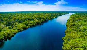
The Amazon forests or ”the lungs” of the Earth. It is one of the most beautiful regions of the planet. It is one of the greatest rivers with a length of 6575 kilometers and it is still the equivalent of the distance from New York City to Rome. Its westernmost source is high in the Andes Mountains, within 100 miles (160 km) of the Pacific Ocean, and its mouth is in the Atlantic Ocean, on the northeastern coast of Brazil. It passes by South American countries which includes Brazil, Colombia, Peru, and Ecuador. Moreover, the widest point the Amazon River can reach is about 11 kilometers. The vast Amazon basin has an area of about 7 million square km.
Two-thirds of the Amazon’s main stream and by far the largest portion of its basin are within Brazil. It is estimated that about one-fifth of all the water that runs off Earth’s surface is carried by the Amazon. Amazon represents over half of the planet’s remaining rainforests, and it comprises the largest and most species-rich tract of tropical rainforest in the world. The diversity of plant species is the highest on Earth. One in ten known species in the world lives in the Amazon Rainforest. If we want to save our planet, we have to preserve the rainforest. The Amazon is home to over 40,000 species of flowering plants and, according to some studies, hosts some 400 billion trees of over 16,000 species. Vertebrates are represented by more than 2200 species of birds, 2500 species of fish, 430 species of mammals, 428 species of amphibians and 378 species of reptiles.
Fires in the Amazon are a fact every year. This year, however, the problem huge. Destroying ”the lungs” of the planet would be devastating to all of humanity. Forests in the Brazilian jungle provide at least 20% of the fresh oxygen in the atmosphere, environmentalists recall.
3.Yangtze River

Yangtze River is the longest river in both China and Asia and it drains an area of 1,808,500 square km. third longest river in the world with a length of 6,300 kilometres. More than three-fourths of the river’s course runs through mountains. its basin is China’s great granary and contains nearly one-third of the national population. The upper Yangtze reaches roar down canyons and valleys from the Tibetan Plateau to Sichuan Province. Ships can’t navigate there. Lijiang is the hub for the main Upper Reaches attractions.
At Lijiang, you can see the Yangtze in one of the world’s deepest canyons, the spectacular Tiger Leaping Gorge, one of China’s best hiking areas. While there, see the UNESCO recognized Naxi minority towns. The river basin of the Yangtze houses one-third of the population of the most populated country in the world i.e., China. Traditionally, the government of China recognizes the Tuotuo tributary located in the Tanggula Mountains as the source of the river. According to new data, however, the source of the Yangtze River is located in the Jari Hill from where the headwaters of the Dam Qu tributary originate. These tributaries, and more join to form the mighty Yangtze River which finally drains into the East China Sea at Shanghai.
It mainly runs across Qinghai-Tibet Plateau, Sichuan, Yunnan, Chongqing, Hubei, Hunan, Jiangxi, Anhui, Jiangsu, and Shanghai from west to east. Yangtze has been an important part of China’s cultural origins and civilization, contributing to the establishment of irrigations systems and water transportation system.
4.Jefferson-Mississippi-Missouri River System

The Jefferson-Mississippi-Missouri River system is the fourth largest river system in the world and serves transportation, industry, and recreation as the most important inland waterway in North America. Its drainage basin collects water from 41% of the contiguous United States, covering a total area of more than 3,224,535 square kilometers and touching 31 U.S. states and 2 Canadian provinces in all. The Mississippi River eventually splits up in to a number of different channels, called distributaries, emptying into the Gulf of Mexico at various points and forming a delta, a triangular shaped alluvial plain composed of silt. It is the second-longest river in North America.
One of the most diverse communities of plants and wildlife in the world exist along the Mississippi. It has one of the largest wetlands in the U.S., visited by 40 percent of all the ducks, geese and swans of North America. A habitat for many plants and animals that are not found elsewhere in the world, such as the paddlefish, it is also a roadmap guiding millions of migratory birds and waterfowl to and from their wintering grounds every year. Countless other wildlife use the river and its floodplain as habitat. More than three hundred species of fish are supported by the Mississippi. Sometimes referred to as “The Big Muddy. Its triangular drainage area covers about 40 percent of the U.S. and includes all or part of 31 states
The Jefferson-Mississippi-Missouri River System begins in Montana at the Red Rocks River and ends at the Red River with the Mississippi River, at the north of Marksville, Louisiana. The river system, with a total length of 6,352 kilometers, serves for transportation, industry, and recreation. In the past, Native Americans were among the first to make use of the river system, routinely canoeing, hunting, and drawing water from its far reaches. Today, it is used primarily for industrial transportation, carrying agricultural and manufactured goods, iron, steel, and mine products from one end of the country to the other.
5.Yenisei or Angara

The Yenisei is a river in Siberia and it belongs to the greatest river system that flows into the Arctic Ocean. The Yenisei is the fifth-longest river in the world. It is a little shorter than the Mississippi River, but with 1.5 times the flow. It comes from Mongolia and follows a northern course to the Kara Sea. The river drains a large part of central Siberia. The longest stream following the Yenisei-Angara-Selenga-Ider is about 5539 km long. Its watershed, which includes the world’s largest (by volume) lake, Lake Baikal, holds more water than any other river system. It runs from south to north.
Krasnoyarsk and many neighboring villages are situated on the Yenisei River, one of the largest river systems in the world, which provides power, transportation, food, sport and more to more than a million residents. Throughout the year, Naymushin covers many subjects in the region, with a significant portion taking place on or near the Yenisei River. A major and important feature of the upper part of the Yenisei River Basin is Lake Baikal, considered the deepest and oldest lake in the world, and a major centre of plant and animal endemism.
The Yenisei River is often divided into three sections: the upper Yenisei, from the headwaters to the Tuba River confluence; the middle Yenisei from this confluence to the confluence with the Angara River; and the lower Yenisei from the Angara confluence to its discharge into the Arctic Ocean. Lake Baikal lies in the upper to middle reaches, with the Selenge River inflowing from its Mongolian headwaters and the outflow becoming the Angara River.
6.Yellow River or Huang He River

The name “Yellow River” comes from the huge amounts of “yellow” loess sediment it carries when flowing through the Loess Plateau. It is the world’s major river with the most excessive siltation. It is the river system in the world at the estimated length of 5,464 km (3,395 mi) Originating in the Bayan Har Mountains in Qinghai province of Western China. It flows through nine provinces, and it empties into the Bohai Sea near the city of Dongying in Shandong province. The Yellow River basin has an east–west extent of about 1,900 kilometers and a north–south extent of about . Its total drainage area is about 795,000 square kilometers. The Yellow River or Huang He is the second-longest river in China. The Yellow River is often called “the cradle of Chinese civilization”. The Yellow River or Huang He is the “mother river of China”. Its basin was the center of Chinese politics, economy and culture for over 2,000 years. The Yellow River is the most important water resource for the dry north of China, playing an irreplaceable role in economic development, and agriculture. Since 1960 over 14 dams have been constructed on the river for hydroelectric power, which is vital to northern China’s infrastructure
7.Ob-Irtyish River

The Ob and The Irtyish rivers together form one of the largest river Basins in the world. The Ob basin stretches across Semi-desert areas, grassland, coniferous forests, and plains. The name Irtysh means White River. The Irtysh springs from melting glaciers in the Altai mountains, a mountain range that form a natural border between western Mongolia and Xinjiang, China. The Ob also begins in the Altai range. The river flows into the Gulf of Ob which is an immense bay on the northern coast of the Russian Federation. It’s also used for irrigation of crops, used to supply millions of homes with drinking water, creates hydroelectric power and is a brilliant source of fish. Fifty different species of fish are found in the Ob alone. The 5,568-kilometer-long river system is used for transporting goods, supplying homes with drinking water. It is
one of the world’s strangest and most wonderful landform features—the curvaceous and mesmerizing braided river valley of Russia’s Ob River. Especially interested in the area where the river’s floodplain was wide and the river meandered freely. I knew this was where the river flow would be slow and there would be a buildup of sediment in the river valley. Like other braided rivers, side channels and temporary islands would be created and re-created as the water flowed largely unobstructed across the extensive, flat landscape. The Ob and Irtysh Rivers both have their headwaters in the highlands of the Altai Mountains, on the borders of Mongolia, where peaks reach heights of 13,200 ft (4,000 m) or more. The two rivers start on different sides of this range, however, and do not meet up until both rivers have crossed most of the flat Siberian plains. Irtysh River is With a length of 2,640 miles (4,248 km), it is one of the continent’s longest rivers.
8.Rio de la Plata-Parana River

Rio de la plata,English River Plate, a tapering intrusion of the Atlantic Ocean on the east coast of South America between Uruguay to the north and Argentina to the south. The total area drained is about 3.2 million square kilometres, or about one-fifth of the surface of the continent. Parana meaning is “Father of the Waters” in the Guarani language. Its numerous waterfalls such as the Marimbondo Falls, with a height of 72 feet makes it of little use for navigation. The Paranaba, which also has numerous waterfalls, is formed by many affluents, the northernmost headstream being the Sao Bartolomeu River, which rises just to the east of Brasilia
After the Amazon River, South America has Parana River rising on the plateau of southeast-central Brazil and flowing generally south until it joins the Uruguay River to form the extensive Rio de Plata estuary of the Atlantic Ocean. The river’s drainage basin includes the greater part of southeastern Brazil, Paraguay, southeastern Bolivia, and northern Argentina. Parana River, with a length of 4,880 kilometers, has been used for fishing and for the transport of agricultural products, manufactured goods, and petroleum products.
9.Congo-Chambeshi

Congo-Chambeshi River gets the spotlight when you talk about the deepest river in the world, but it still enters the “longest rivers” list with its length of 4,700 kilometers. According to history, the river served as a source of livelihood in the ancient kingdoms of the Democratic Republic of Congo and the Republic of Congo. When talking about the river’s aquatic life, it possesses the highest known concentrations of endemics. Congo River, formerly Zaire River in west-central Africa. Its course then takes the form of a giant counterclockwise arc, flowing to the northwest, west, and southwest before draining into the Atlantic Ocean at Banana (Banane) in the Democratic Republic of the Congo. Its drainage basin, covering an area of 3,457,000 square km.
This extensive body of water provides food, water, medicine and transport to about 75 million people in the surrounding basin, according to Yale University’s Global Forest Atlas. The Congo River is the world’s deepest recorded river at 720 feet (220 meters) deep in parts. Congo River holds an abundance of valuable resources, from ivory to rubber to timber “It’s this massive freshwater heart of Africa,”
10.Amur-Argun

Its length is 1,007 miles (1,620 km), of which about 600 miles (965 km) form the boundary . Argun River rising in the Inner Mongolia Autonomous Region of China, on the western slope of the Greater Khingan Range, where it is known as the Hailar River. The Amur-Argun River has a length of 4,444 kilometers. Besides being one of the longest rivers, It holds the title as having the tenth biggest basin area and the third longest undammed river in the world, after the Amazon and the Lena. Amur River starts in Russia and meets Argun River at the Inner Mongolia region of China. The Amur’s most important tributaries include the Zeya, Bureya, and Amgun rivers, which enter on the left bank from Siberia.
The river is divided into three sections: the upper, middle, and lower Amur. The upper Amur begins at the juncture of the Shilka and Argun and ends at the mouth of the Zeya, about 900 km downstream. The middle Amur extends about 970 km from the Zeya east to Khabarovsk. The lower Amur, from Khabarovsk to the mouth, also is about 970 km long.